


History of Cape Canaveral Chapter 1
By Cliff Lethbridge
Origin Of Cape Canaveral Remains Largely A Mystery
Although the recorded history of Cape Canaveral dates back a remarkable 500 years, next to nothing is known about when and how Cape Canaveral formed, or what exactly happened there prior to the advent of Spanish colonial exploration.
It is generally believed that geographic Cape Canaveral, as it is known today, was likely underwater for untold thousands of years. There is ample geological evidence of ancient dune lines, where ocean waves once broke upon the shoreline.
Actually, these dune lines run north and south along the Florida mainland about 10 to 15 miles inland from present day Cape Canaveral. Huge numbers of indigenous sea shells are commonly found at any inland construction site where deep digging is conducted.
What is nearly certain is that at some point in time, the ocean waves receded, and a combination of tidal action and local topography allowed a small point of land to jut out from the coastline into the great sea.
Imagination must of necessity rule when trying to imagine what the area was like before human intervention. Cape Canaveral likely played host to a huge variety of flora and fauna, including just about any creature that could fly, walk or crawl to its shores.
Even the great wooly mammoths once roamed the Florida mainland, and perhaps even these animals ambled across the coastal shallows to graze on this ancient landscape.
While little is known about the origin and ancient history of this now famous stretch of sand and scrub, some light has been shed on the original human inhabitants of the region.
Ancient Residents Of Cape Canaveral Area Are Unearthed
Historians believe that the first residents of Florida were Native Americans who migrated to the region about 10,000 years ago. As far as the area surrounding Cape Canaveral is concerned, a most remarkable discovery was made in the mid-1980’s.
A heavy machine operator excavating a peat bog near Interstate-95 in Titusville, located on the Florida mainland a few miles west of Cape Canaveral, unearthed a human skull. Believing this to be the victim of some horrendous crime, the worker promptly called authorities.
But the skull would prove to be one of the greatest anthropological finds in the history of Florida. The skull turned out to be very old, and was turned over to researchers with Florida State University.
The entire area was sealed off, and researchers decided to completely drain a nearby pond. Excavation of the peat material in the banks and bottom of the pond revealed a treasure trove of bones belonging to some of the area’s oldest inhabitants.
A rare environmental mix in the peat bog area served to preserve in near pristine condition human bones and plants from a bygone era. Several of the human skulls even contained preserved brain tissue.
Although the remains will be studied for years to come, a great deal has been learned about the people who were most likely the Cape Canaveral area’s first inhabitants.
Scientists believe the Titusville remains belong to Native Americans inhabiting the area about 7,000 years ago. Due to the condition of tooth remains, it is believed these Indians ate mainly coarse vegetation and grains. This led to speculation that the tribe was migratory in nature.
Although believed to be migratory, the discovery of so many bones in one location would point to a more permanent presence in the area, or at least a significance of the area to these people.
Since so many bones were found in and around the pond, it is believed it was used as a burial pond, in which the remains of deceased individuals would be placed. All else about these early Floridians, including their relationship to later identifiable inhabitants, is a mystery.
Modern Clues About Native American Inhabitants Of Cape Canaveral Abound
But much more is known about the Native Americans who populated the Cape Canaveral area in colonial times. Archaeological discoveries in recent years have indicated that a wide range of Native American groups left their marks in the area.
Cultures are known to have varied, with some being hunters, fishermen, migratory crop gatherers and agriculturists. Some used bones for tools and jewelry and animal skins for clothing. Clues about these people are found through the excavation of “middens”, also called “Indian mounds”.
Literally hundreds of middens are located on Cape Canaveral and the surrounding areas. Although middens on the Cape are currently protected, a large number were destroyed when full-scale construction of missile range facilities was begun.
Each midden is typically several feet thick and contains the remains of coquina, whelk and clam shells. In addition, many middens have been found to contain artifacts. Many of these historical treasures literally went home with the original Cape construction workers. But, much of the material has been well preserved for study and display.
Two Native American Groups Populate Cape Canaveral Region
It is generally believed that two main groups of Native Americans populated the Cape Canaveral area leading up to colonial times. These are the Ais and Timucuans, both of whom frequented the Cape Canaveral area due its local abundance of seafood and edible vegetation.
The Ais are believed to have populated the coastal area along the Indian River, originally called “Rio de Ais” (River of the Ais) from the Cape Canaveral area south to the St. Lucie River and extending perhaps as many as 30 miles inland. The Timucuans are believed to have populated a large area extending from Cape Canaveral north to Georgia.
The Ais were fiercely warlike and nonagricultural, and survived chiefly on seafood and indigenous vegetation. They were known to be cannibals, and were greatly feared by other Native American tribes and European explorers. The Ais hated the Spanish, and were the chief reason the Cape Canaveral area was not colonized by Spanish settlers.
A large number of Spanish shipwrecks were plundered by the Ais, who very rarely took prisoners. In time, the Ais added the Spanish knife and hatchet to their arsenal of primitive bow and arrow. They also salvaged tons of Spanish silver and gold, which is periodically discovered hidden in middens.
The Timucuans were docile in comparison to the Ais, although they also are known to have been cannibals. Still, the Timucuans were primarily hunters and fishermen, and also raised crops. Their agricultural activities often resulted in a surplus, which was stored in granaries.
Neither the Timucuans nor the Ais initially welcomed European explorers with open arms. They had good reason to fear the Spanish in particular. When Spanish forces were strong enough to subdue the Native Americans, many were forced to perform slave labor. This typically involved forced diving and labor at the site of Spanish shipwreck salvage sites.
By the time the Cape Canaveral area was colonized, neither the Ais nor Timucuan tribes survived. It is not known whether they were the victims of European-introduced diseases or inter-tribal warfare. Both were common in colonial times.
The Ais and Timucuan tribes should not be confused with the Seminoles, who did not migrate into Florida until the 1700’s. Seminoles were not common in the area around Cape Canaveral, but are known to have traded with American settlers in the Merritt Island area as late as the 1860’s.
Spaniard Ponce De Leon Explores Cape Canaveral
Although maps containing the rough geographic boundaries of Cape Canaveral, albeit without a name, are dated as early as 1502, Spanish explorer Ponce de Leon has been credited with first exploring the region in 1513. His second landing in Florida was just south of Cape Canaveral, probably near the present day town of Melbourne Beach.
Ponce de Leon was forced to retreat hastily from the area after being attacked by fierce inhabitants, probably the Ais. He did, however, have time to secure water and food, if no information on the famed “Fountain of Youth” treasure being sought.
Unfortunately, the exact circumstances surrounding the naming of Cape Canaveral remain a mystery, although the oldest known map containing the name Cape Canaveral was made in 1564, well after the initial landing by Ponce de Leon. It is known, however, that the name Cape Canaveral is of Spanish origin.
Some of the oldest surviving Spanish maps of Cape Canaveral refer to the area as the “Cape of Currents”, because sailors wanted to avoid this coastline due to dangerous waters and a better than average chance for shipwreck. This name was ultimately abandoned in favor of “Cape Canaveral”, a name which has long endured.
The name “Cape Canaveral” is made up of two fairly simple Spanish words. The name “Cape” was simply the designation for a point of land jutting out into the sea. “Canaveral”, literally translated “canebrake”, might have had a number of different meanings depending upon who actually selected the name.
The Smithsonian Institution included an account of the naming of Cape Canaveral in their 1992 traveling exhibition celebrating the 500th anniversary of the voyage of Christopher Columbus. According to the exhibit, Cape Canaveral, translated as “Place of the Cane Bearers”, was named by Spanish Cape explorer Francisco Gordillo after he was shot by an Ais arrow made of cane.
Cape Canaveral has also been roughly translated as “Point of Reeds” or “Point of Canes”. While there is no actual sugar cane indigenous to the Cape Canaveral area, there are several forms of plants that resemble sugar cane. These include a type of bamboo reed dubbed “nomal cane” by early U.S. residents of the Cape. This plant very much resembles sugar cane when seen from offshore.
It is more likely that the traditional account of the naming of Cape Canaveral is correct, that Spanish sailors named the area Cape Canaveral because they believed they saw sugar cane growing along the coastline. There is no clearly defined historical account of where the name actually came from.
Cape Canaveral Remains Uncolonized But Is A Vital Landmark
Several decades after the visit of Ponce de Leon, Florida remained relatively untouched by the Spanish, primarily due to a lack of indigenous treasure and an abundance of hostile inhabitants. However, Cape Canaveral itself quickly became a vital landmark.
Even the oldest known maps of Florida contain two important landmarks. These are the Florida Keys and Cape Canaveral. At the time, dead reckoning was the means of plotting the course of a ship. Therefore, ships typically remained within visual range of the coastline and used it as a reference point.
The Florida Keys were instrumental in locating the eastern coast of Florida, which was sailed along during trips back to Spain. Cape Canaveral was a vital landmark for sailors, who typically turned toward the northeast after it was sighted.
After following the Gulf Stream and prevailing winds to Bermuda and the Azores, these ships continued on across the Atlantic Ocean to Europe. However, shallow waters along the coast of Florida as well as unpredictable hurricanes plagued sailors for generations.
Since so many ships sailed the area near Cape Canaveral, it remains one of the most common colonial shipwreck sites in the world, and a popular starting point in the search for treasure, which litters the Atlantic waters from Cape Canaveral southward.
The French Settle And Rename Cape Canaveral
It is little known that one of the first attempted European settlements on North America was near Cape Canaveral. In the early 1560’s, Frenchman Jean Ribault was commissioned to establish permanent settlements in Florida. French settlement would be extremely dangerous, since the Spanish dominated the seas and reacted swiftly and violently to French piracy, whether actual or perceived.
During the Ribault campaign to establish settlements, a ship named “Trinity” was wrecked north of Cape Canaveral, on what is now called the Cape Canaveral National Seashore. The shipwrecked party was able to establish a settlement nearby, and promptly renamed Cape Canaveral “French Cape”.
The French party was able to do something the Spanish had not been able to. They established and maintained peaceful relations with the local Native American inhabitants. Establishment of this settlement and similar efforts by Ribault brought swift reprisal from the Spanish.
The Spanish Quickly Uproot The French Settlers
Sensing a threat to their own interests, the Spanish commissioned Pedro Menendez de Aviles to establish settlements and drive the French from Florida. The greatest concentration of French settlers had established a village on the northern Atlantic coast of Florida.
Pedro Menendez de Aviles quickly uprooted these settlers, murdering many, including Jean Ribault, under a flag of truce. Some of the French settlers evaded the Spanish, and fled south to the settlement at “French Cape”. Their intention was to build an escape vessel out of the remains of the ship “Trinity” and head back to France.
In 1565, a permanent Spanish settlement was established and named St. Augustine, an area previously occupied by the French. St. Augustine remains the oldest permanent European settlement in North America. The Spanish quickly headed south to establish a settlement at strategic Cape Canaveral.
The Spanish succeeded in uprooting the French settlement at the Cape. Most of the French settlers were taken prisoner, but about 20 are believed to have sought refuge at an Ais Indian village on the Indian River.
Immediately after removing the French settlers, the Spanish attempted to build a permanent fort at Cape Canaveral, primarily for the purpose of protecting shipwrecked sailors from attack. In 1565, the same year St. Augustine was established, a Spanish blockhouse was built at the northern tip of the Indian River.
This was followed by a gradual movement of Spanish forces to the south. Several small fortifications were erected on Cape Canaveral, traces of which have been found and preserved. However, relentless attacks from the Ais resulted in a complete Spanish abandonment of Cape Canaveral within a few months.
Although Cape Canaveral remained a vital landmark for sailors in the years that followed, the area was untouched by settlers for nearly three centuries.
British Flag Briefly Flies Over Florida
Florida became a British possession as a result of the Treaty of Paris in 1763. British settlers were moderately successful at establishing colonies in Florida, although Cape Canaveral itself was not affected. The nearest British settlement in relation to Cape Canaveral was New Smyrna to the north, settled by Dr. Andrew Turnbull in 1767.
Cape Canaveral Becomes U.S. Possession By War
Cape Canaveral, along with the rest of Florida, became a possession of the United States as a result of the Revolutionary War. In fact, the last naval battle of the Revolutionary War was fought about 72 miles southeast of Cape Canaveral.
On March 10, 1783 the British ship HMS Sybil challenged the French-built ship Duc de Lausun and the American ship Alliance. The British ship, as well as three others which gave chase later, were successfully outgunned and driven off by the Alliance.
Upon the conclusion of the War of 1812, Cape Canaveral would remain under the flag of the United States.
Cape Canaveral Remains Unsettled Until U.S. Expands Southward
As the borders of the United States continued to expand, the first American settlers slowly trickled into Florida. At the age of 23, Douglas D. Dummitt established the first permanent settlement in the Cape Canaveral area. By 1828, Dummitt was able to ship commercial quantities of oranges northward along the Indian River.
Dummitt Grove was located on Merritt Island, directly west of Cape Canaveral with the Indian River to the west and the Banana River to the east. Much of the original Dummitt Grove is today located on Kennedy Space Center property. Dummitt operated an orange grove on this land until his death in 1872.
Cape Canaveral itself, however, did not receive its first American inhabitants until a few decades later. As the Dummitt groves were growing and thriving to the west Cape Canaveral remained very isolated.
In the 1840’s the first group of settlers established permanent residence on geographic Cape Canaveral. These were hearty souls from Georgia and the Carolinas, mostly of English and Scott-Irish heritage. Today there are still people who can trace their lineage back to these settlers.
The first Cape Canaveral settlers occupied just a few households, but were able to maintain a self-reliant existence at what at the time was a hostile environment marked by brutal heat, plagues of mosquitoes, a challenging sand and scrub environment in which to grow crops and most of all isolation from other people.
Cape Canaveral Gets An Enduring Lighthouse
In 1843, the U.S. government selected Cape Canaveral as the site for a permanent lighthouse. The eastern tip of the Cape made a natural choice for this vital aid to navigation. Construction of the original Cape Canaveral Lighthouse, made of brick, was completed in 1847. The original lighthouse was dismantled during the Civil War, although a brand new lighthouse, built of steel, was already designed and planned in the early 1860’s for installation at the Cape. Installation of the new lighthouse was delayed by the war but it was ultimately completed in 1868. In 1894, the Cape Canaveral Lighthouse was relocated from the immediate coastline to about a mile inland because of the threat of erosion. There the lighthouse stands to this very day.
The Florida Mainland Population West Of Cape Canaveral Expands Rapidly
Originally called St. Lucie, the Florida mainland territory west of Cape Canaveral along the western bank of the Indian River was renamed Brevard County in 1855. The name has not changed, and today Brevard County, Florida includes all of Cape Canaveral and the Kennedy Space Center.
Regardless of this designation as a county, there were still no roads or railroads in the area, and travel to and from Brevard County was possible only by boat. Initially, this made travel irregular and difficult.
However, by the 1880’s, a regular line of steamer traffic was established from the St. John’s River in north Florida south to the Indian River in Brevard County. While this did not expand the population of isolated Cape Canaveral, it did expand the population of the mainland area to the west.
Mainland areas to the west of Cape Canaveral experienced a steady growth through the 1890’s, when a railroad line was extended into Brevard County. By June, 1893 the Flagler Railway reached the city of Titusville, formerly called Sand Point, at the northern end of Brevard County.
Titusville had been a popular port as early as the 1880’s, and featured a mule-driven railroad that carried goods to western settlers in what is now the Orlando area. The Flagler Railway was quickly extended southward along the western bank of the Indian River through the cities of Cocoa, Rockledge and Eau Gallie.
Cocoa, formerly called Indian River City and located about ten miles south of Titusville, was settled in 1881. Rockledge, just south of Cocoa and formerly called Rock Ledge after coquina rock which extended into the Indian River, was settled in 1873 as the first winter resort community on the east coast of Florida.
Eau Gallie, just north of the city of Melbourne and located about 20 miles south of Rockledge, was also settled in the 1870’s. Eau Gallie was eventually absorbed into the city of Melbourne, which itself was established in the early 1880’s.
Once the Flagler Railway reached Eau Gallie, the entire mainland area west of Cape Canaveral was served by a railroad. The Titusville, Cocoa and Melbourne areas soon emerged as major centers of local population.
Still, Cape Canaveral remained isolated. Although population was gradually increasing on the mainland, just a few more families settled on Cape Canaveral, which was separated from the mainland by the Banana River, Merritt Island and the Indian River, traveling from east to west.
Merritt Island, originally settled by Dummitt, did not itself experience an influx of settlers until 1868, when agriculturists established citrus, pineapple and sugar cane plantations. Cattle was also raised on Merritt Island, which to date has never been incorporated as a city.
The barrier island area south of Cape Canaveral was not settled until 1923, when the first bridge was extended from Merritt Island eastward to the Atlantic coast. The eastern terminus of this bridge was incorporated as the city of Cocoa Beach in 1925.
Cape Canaveral Is Settled Under The Homestead Act
With population now creeping closer and closer, Cape Canaveral was opened to settlement under the Homestead Act. As the relative prosperity of the 1920’s dawned, families and small businesses trickled onto Cape Canaveral. The area still remained isolated.
There were no permanent roads, and trips to and from the surrounding mainland areas took the better part of a day to complete. Nevertheless, several small villages emerged on Cape Canaveral under the wary eyes of those hearty families who had settled the Cape nearly a century earlier.
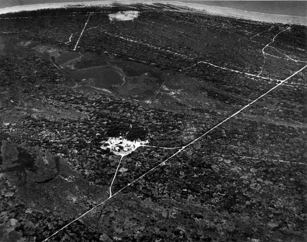
The primary villages on Cape Canaveral, traces of which are still evident today, included Artesia, located on the extreme south end of the Cape. Artesia was completely abandoned and destroyed when Port Canaveral was constructed.
A settlement nicknamed Stinkmore was located on the Cape Canaveral southeast shoreline, near present day Launch Complex 17 and just a stone’s throw from Launch Pad 5 where America’s first astronaut was launched. The most striking feature of Stinkmore was an elaborate fishing pier and dock that stretched about 300 feet into the Atlantic waters.
The most developed and populated area of Cape Canaveral was known as DeSoto Beach, and was located in the vicinity of present day Launch Complex 36. DeSoto Beach featured perhaps 15 permanent homes, a small hotel, a store and even a brothel.
A collection of other homes and structures dotted the Cape Canaveral coastline, and were included in a more or less generic and unofficial designation as Cape Canaveral or Canaveral Beaches.
Farther to the north of Cape Canaveral on what is called False Cape, technically the eastern edge of Merritt Island, towns named Nathan and Titusville Beach were settled. Remains of these towns are located near the present day Launch Pads 39A and 39B.
Although the permanent Cape Canaveral population numbered about 100 at the dawn of World War II, the area catered to numerous visitors, including many fishermen who sought to take advantage of the excellent fishing the Cape waters provided.
The Threat Of War Begins To Shape The Future Of Cape Canaveral
Events that shaped the future of Cape Canaveral began just prior to World War II. Under the Naval Expansion Act of 1938, two naval installations to reinforce the Atlantic Coast Defense System were authorized for construction on the east coast of Florida.
The first was to be located in Jacksonville, and the second was proposed for Brevard County. In June, 1939 Commander W.M. Angus, Public Works Officer for the Seventh Naval District, met with civic leaders of Melbourne, Eau Gallie and Cocoa to settle on a site.
A narrow strip of the barrier island located roughly between the Melbourne and Cocoa areas was selected as the site for a naval air station. Construction was begun in December, 1939 and the resulting Banana River Naval Air Station was commissioned on October 1, 1940. It covered 1,791 acres and was roughly 4.1 miles long by 1.25 miles wide.
In addition to supporting coastal seaplane patrol operations during World War II, Banana River Naval Air Station operated a PBM seaplane pilot training program and advanced navigation school. Although the facility continued to support the Navy after World War II, it was officially deactivated on August 1, 1947.
Although Banana River Naval Air Station property could have been quickly abandoned and turned over to the local communities, the area was maintained on caretaker status until an important decision could be made.